|
| at: |
Angelina National Forest |
Data from USFS GIS
 show on map
 animate
Trail users:


Elevation Profile
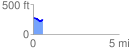
 0.563951 mi
 23.94 ft
 66.73 ft
 -42.79 ft
 2.24 %
GPX Downloads: Track Route
![]()
|
| at: |
Angelina National Forest |
show on map
animate
0.563951 mi
23.94 ft
66.73 ft
-42.79 ft
2.24 %