|
| at: |
Angelina National Forest |
Data from USFS GIS
 show on map
 animate
Trail users:


Elevation Profile
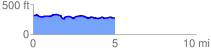
 5.129050 mi
 251.15 ft
 280.53 ft
 -29.38 ft
 1.04 %
GPX Downloads: Track Route
![]()
|
| at: |
Angelina National Forest |
show on map
animate
5.129050 mi
251.15 ft
280.53 ft
-29.38 ft
1.04 %