|
| at: |
Angelina National Forest |
Data from USFS GIS
 show on map
 animate
Trail users:


Elevation Profile
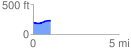
 1.000382 mi
 46.13 ft
 19.75 ft
 26.38 ft
 0.87 %
GPX Downloads: Track Route
![]()
|
| at: |
Angelina National Forest |
show on map
animate
1.000382 mi
46.13 ft
19.75 ft
26.38 ft
0.87 %