| at: |
Angelina National Forest |
Data from USFS GIS
 show on map
 animate
Trail users:


Elevation Profile
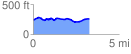
 3.303185 mi
 199.06 ft
 184.37 ft
 14.69 ft
 1.14 %
GPX Downloads: Track Route
![]()
| at: |
Angelina National Forest |
show on map
animate
3.303185 mi
199.06 ft
184.37 ft
14.69 ft
1.14 %