| at: |
Angelina National Forest |
Data from USFS GIS
 show on map
 animate
Trail users:


Elevation Profile
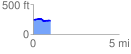
 1.002089 mi
 46.83 ft
 68.62 ft
 -21.78 ft
 1.30 %
GPX Downloads: Track Route
![]()
| at: |
Angelina National Forest |
show on map
animate
1.002089 mi
46.83 ft
68.62 ft
-21.78 ft
1.30 %