| at: |
Angelina National Forest |
Data from USFS GIS
 show on map
 animate
Trail users:


Elevation Profile
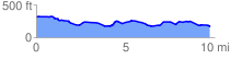
 9.745442 mi
 390.39 ft
 550.12 ft
 -159.73 ft
 1.07 %
GPX Downloads: Track Route
![]()
| at: |
Angelina National Forest |
show on map
animate
9.745442 mi
390.39 ft
550.12 ft
-159.73 ft
1.07 %