| at: |
Angelina National Forest |
Data from USFS GIS
 show on map
 animate
Trail users:


Elevation Profile
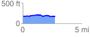
 2.760525 mi
 111.96 ft
 102.86 ft
 9.10 ft
 0.77 %
GPX Downloads: Track Route
![]()
| at: |
Angelina National Forest |
show on map
animate
2.760525 mi
111.96 ft
102.86 ft
9.10 ft
0.77 %