| at: |
Angelina National Forest |
Data from USFS GIS
 show on map
 animate
Trail users:


Elevation Profile
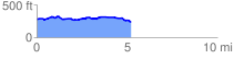
 5.278850 mi
 239.81 ft
 276.19 ft
 -36.38 ft
 0.99 %
GPX Downloads: Track Route
![]()
| at: |
Angelina National Forest |
show on map
animate
5.278850 mi
239.81 ft
276.19 ft
-36.38 ft
0.99 %