| at: |
Angelina National Forest |
Data from USFS GIS
 show on map
 animate
Trail users:


Elevation Profile
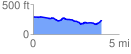
 3.982095 mi
 177.82 ft
 230.49 ft
 -52.66 ft
 1.10 %
GPX Downloads: Track Route
![]()
| at: |
Angelina National Forest |
show on map
animate
3.982095 mi
177.82 ft
230.49 ft
-52.66 ft
1.10 %