| at: |
Angelina National Forest |
Data from USFS GIS
 show on map
 animate
Trail users:


Elevation Profile
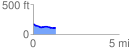
 1.305345 mi
 19.62 ft
 90.30 ft
 -70.67 ft
 1.31 %
GPX Downloads: Track Route
![]()
| at: |
Angelina National Forest |
show on map
animate
1.305345 mi
19.62 ft
90.30 ft
-70.67 ft
1.31 %