| at: |
Angelina National Forest |
Data from USFS GIS
 show on map
 animate
Trail users:


Elevation Profile
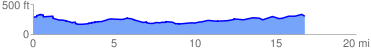
 17.257226 mi
 628.54 ft
 606.51 ft
 22.03 ft
 0.69 %
GPX Downloads: Track Route
![]()
| at: |
Angelina National Forest |
show on map
animate
17.257226 mi
628.54 ft
606.51 ft
22.03 ft
0.69 %