| at: |
Angelina National Forest |
Data from USFS GIS
 show on map
 animate
Trail users:


Elevation Profile
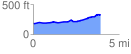
 3.901294 mi
 198.73 ft
 56.31 ft
 142.42 ft
 0.96 %
GPX Downloads: Track Route
![]()
| at: |
Angelina National Forest |
show on map
animate
3.901294 mi
198.73 ft
56.31 ft
142.42 ft
0.96 %