| at: |
Angelina National Forest |
Data from USFS GIS
 show on map
 animate
Trail users:


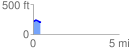
Elevation Profile
 0.435889 mi
 31.28 ft
 36.11 ft
 -4.82 ft
 1.57 %
GPX Downloads: Track Route
![]()
| at: |
Angelina National Forest |
show on map
animate
0.435889 mi
31.28 ft
36.11 ft
-4.82 ft
1.57 %