| at: |
Angelina National Forest |
Data from USFS GIS
 show on map
 animate
Trail users:


Elevation Profile
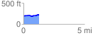
 1.253950 mi
 63.61 ft
 36.43 ft
 27.19 ft
 0.96 %
GPX Downloads: Track Route
![]()
| at: |
Angelina National Forest |
show on map
animate
1.253950 mi
63.61 ft
36.43 ft
27.19 ft
0.96 %