| at: |
Angelina National Forest |
Data from USFS GIS
 show on map
 animate
Trail users:


Elevation Profile
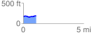
 1.081831 mi
 48.16 ft
 38.67 ft
 9.49 ft
 0.84 %
GPX Downloads: Track Route
![]()
| at: |
Angelina National Forest |
show on map
animate
1.081831 mi
48.16 ft
38.67 ft
9.49 ft
0.84 %