| at: |
Angelina National Forest |
Data from USFS GIS
 show on map
 animate
Trail users:


Elevation Profile
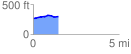
 1.452134 mi
 68.80 ft
 34.62 ft
 34.17 ft
 0.90 %
GPX Downloads: Track Route
![]()
| at: |
Angelina National Forest |
show on map
animate
1.452134 mi
68.80 ft
34.62 ft
34.17 ft
0.90 %