| at: |
Angelina National Forest |
Data from USFS GIS
 show on map
 animate
Trail users:


Elevation Profile
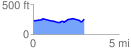
 2.990984 mi
 155.34 ft
 129.89 ft
 25.45 ft
 0.98 %
GPX Downloads: Track Route
![]()
| at: |
Angelina National Forest |
show on map
animate
2.990984 mi
155.34 ft
129.89 ft
25.45 ft
0.98 %