| at: |
Angelina National Forest |
Data from USFS GIS
 show on map
 animate
Trail users:


Elevation Profile
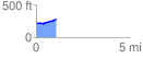
 1.082429 mi
 77.17 ft
 9.78 ft
 67.39 ft
 1.35 %
GPX Downloads: Track Route
![]()
| at: |
Angelina National Forest |
show on map
animate
1.082429 mi
77.17 ft
9.78 ft
67.39 ft
1.35 %