| at: |
Angelina National Forest |
Data from USFS GIS
 show on map
 animate
Trail users:


Elevation Profile
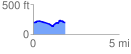
 1.853653 mi
 128.91 ft
 129.07 ft
 -0.16 ft
 1.32 %
GPX Downloads: Track Route
![]()
| at: |
Angelina National Forest |
show on map
animate
1.853653 mi
128.91 ft
129.07 ft
-0.16 ft
1.32 %