| at: |
Angelina National Forest |
Data from USFS GIS
 show on map
 animate
Trail users:


Elevation Profile
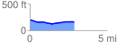
 2.852251 mi
 46.11 ft
 85.58 ft
 -39.47 ft
 0.57 %
GPX Downloads: Track Route
![]()
| at: |
Angelina National Forest |
show on map
animate
2.852251 mi
46.11 ft
85.58 ft
-39.47 ft
0.57 %