| at: |
Angelina National Forest |
Data from USFS GIS
 show on map
 animate
Trail users:


Elevation Profile
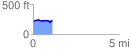
 1.120849 mi
 52.93 ft
 43.12 ft
 9.81 ft
 0.89 %
GPX Downloads: Track Route
![]()
| at: |
Angelina National Forest |
show on map
animate
1.120849 mi
52.93 ft
43.12 ft
9.81 ft
0.89 %