|
| at: |
Angelina National Forest |
Data from USFS GIS
 show on map
 animate
Trail users:


Elevation Profile
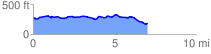
 7.095724 mi
 292.55 ft
 381.11 ft
 -88.56 ft
 1.02 %
GPX Downloads: Track Route
![]()
|
| at: |
Angelina National Forest |
show on map
animate
7.095724 mi
292.55 ft
381.11 ft
-88.56 ft
1.02 %