| at: |
Angelina National Forest |
Data from USFS GIS
 show on map
 animate
Trail users:


Elevation Profile
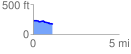
 1.137604 mi
 16.84 ft
 67.35 ft
 -50.51 ft
 1.12 %
GPX Downloads: Track Route
![]()
| at: |
Angelina National Forest |
show on map
animate
1.137604 mi
16.84 ft
67.35 ft
-50.51 ft
1.12 %