| at: |
Angelina National Forest |
Data from USFS GIS
 show on map
 animate
Trail users:


Elevation Profile
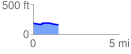
 1.452662 mi
 28.54 ft
 52.25 ft
 -23.71 ft
 0.68 %
GPX Downloads: Track Route
![]()
| at: |
Angelina National Forest |
show on map
animate
1.452662 mi
28.54 ft
52.25 ft
-23.71 ft
0.68 %