| at: |
Angelina National Forest |
Data from USFS GIS
 show on map
 animate
Trail users:


Elevation Profile
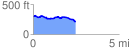
 2.499033 mi
 112.10 ft
 195.07 ft
 -82.98 ft
 1.48 %
GPX Downloads: Track Route
![]()
| at: |
Angelina National Forest |
show on map
animate
2.499033 mi
112.10 ft
195.07 ft
-82.98 ft
1.48 %