| at: |
Angelina National Forest |
Data from USFS GIS
 show on map
 animate
Trail users:


Elevation Profile
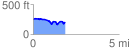
 1.899501 mi
 144.38 ft
 194.82 ft
 -50.44 ft
 1.94 %
GPX Downloads: Track Route
![]()
| at: |
Angelina National Forest |
show on map
animate
1.899501 mi
144.38 ft
194.82 ft
-50.44 ft
1.94 %