| at: |
Angelina National Forest |
Data from USFS GIS
 show on map
 animate
Trail users:


Elevation Profile
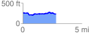
 2.860465 mi
 140.39 ft
 177.84 ft
 -37.45 ft
 1.18 %
GPX Downloads: Track Route
![]()
| at: |
Angelina National Forest |
show on map
animate
2.860465 mi
140.39 ft
177.84 ft
-37.45 ft
1.18 %