| at: |
Angelina National Forest |
Data from USFS GIS
 show on map
 animate
Trail users:


Elevation Profile
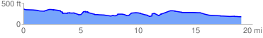
 19.227963 mi
 669.95 ft
 869.19 ft
 -199.24 ft
 0.86 %
GPX Downloads: Track Route
![]()
| at: |
Angelina National Forest |
show on map
animate
19.227963 mi
669.95 ft
869.19 ft
-199.24 ft
0.86 %