| at: |
Angelina National Forest |
Data from USFS GIS
 show on map
 animate
Trail users:


Elevation Profile
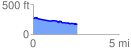
 2.562211 mi
 50.82 ft
 144.19 ft
 -93.37 ft
 1.07 %
GPX Downloads: Track Route
![]()
| at: |
Angelina National Forest |
show on map
animate
2.562211 mi
50.82 ft
144.19 ft
-93.37 ft
1.07 %