| at: |
Angelina National Forest |
Data from USFS GIS
 show on map
 animate
Trail users:


Elevation Profile
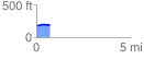
 0.708167 mi
 35.59 ft
 16.26 ft
 19.33 ft
 0.95 %
GPX Downloads: Track Route
![]()
| at: |
Angelina National Forest |
show on map
animate
0.708167 mi
35.59 ft
16.26 ft
19.33 ft
0.95 %