| at: |
Angelina National Forest |
Data from USFS GIS
 show on map
 animate
Trail users:


Elevation Profile
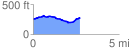
 2.733832 mi
 163.87 ft
 135.23 ft
 28.63 ft
 1.14 %
GPX Downloads: Track Route
![]()
| at: |
Angelina National Forest |
show on map
animate
2.733832 mi
163.87 ft
135.23 ft
28.63 ft
1.14 %