| at: |
Angelina National Forest |
Data from USFS GIS
 show on map
 animate
Trail users:


Elevation Profile
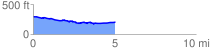
 5.087964 mi
 126.52 ft
 214.21 ft
 -87.70 ft
 0.80 %
GPX Downloads: Track Route
![]()
| at: |
Angelina National Forest |
show on map
animate
5.087964 mi
126.52 ft
214.21 ft
-87.70 ft
0.80 %