| at: |
Angelina National Forest |
Data from USFS GIS
 show on map
 animate
Trail users:


Elevation Profile
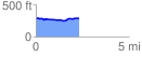
 2.347856 mi
 90.07 ft
 84.07 ft
 6.01 ft
 0.73 %
GPX Downloads: Track Route
![]()
| at: |
Angelina National Forest |
show on map
animate
2.347856 mi
90.07 ft
84.07 ft
6.01 ft
0.73 %