| at: |
Angelina National Forest |
Data from USFS GIS
 show on map
 animate
Trail users:


Elevation Profile
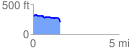
 1.576592 mi
 51.85 ft
 156.65 ft
 -104.79 ft
 1.88 %
GPX Downloads: Track Route
![]()
| at: |
Angelina National Forest |
show on map
animate
1.576592 mi
51.85 ft
156.65 ft
-104.79 ft
1.88 %