| at: |
Angelina National Forest |
Data from USFS GIS
 show on map
 animate
Trail users:


Elevation Profile
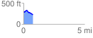
 0.785296 mi
 50.77 ft
 109.73 ft
 -58.96 ft
 2.65 %
GPX Downloads: Track Route
![]()
| at: |
Angelina National Forest |
show on map
animate
0.785296 mi
50.77 ft
109.73 ft
-58.96 ft
2.65 %