| at: |
Angelina National Forest |
Data from USFS GIS
 show on map
 animate
Trail users:


Elevation Profile
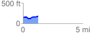
 1.255767 mi
 86.33 ft
 59.26 ft
 27.07 ft
 1.30 %
GPX Downloads: Track Route
![]()
| at: |
Angelina National Forest |
show on map
animate
1.255767 mi
86.33 ft
59.26 ft
27.07 ft
1.30 %