|
| at: |
Angelina National Forest |
Data from USFS GIS
 show on map
 animate
Trail users:


Elevation Profile
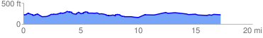
 17.811753 mi
 693.70 ft
 698.73 ft
 -5.03 ft
 0.74 %
GPX Downloads: Track Route
![]()
|
| at: |
Angelina National Forest |
show on map
animate
17.811753 mi
693.70 ft
698.73 ft
-5.03 ft
0.74 %