| at: |
Angelina National Forest |
Data from USFS GIS
 show on map
 animate
Trail users:


Elevation Profile
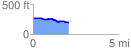
 2.086816 mi
 37.47 ft
 116.89 ft
 -79.41 ft
 1.06 %
GPX Downloads: Track Route
![]()
| at: |
Angelina National Forest |
show on map
animate
2.086816 mi
37.47 ft
116.89 ft
-79.41 ft
1.06 %