| at: |
Angelina National Forest |
Data from USFS GIS
 show on map
 animate
Trail users:


Elevation Profile
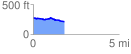
 1.829276 mi
 53.58 ft
 109.66 ft
 -56.08 ft
 1.14 %
GPX Downloads: Track Route
![]()
| at: |
Angelina National Forest |
show on map
animate
1.829276 mi
53.58 ft
109.66 ft
-56.08 ft
1.14 %