| at: |
Angelina National Forest |
Data from USFS GIS
 show on map
 animate
Trail users:

Elevation Profile
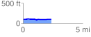
 2.385782 mi
 49.03 ft
 49.95 ft
 -0.92 ft
 0.40 %
GPX Downloads: Track Route
![]()
| at: |
Angelina National Forest |
show on map
animate
2.385782 mi
49.03 ft
49.95 ft
-0.92 ft
0.40 %