| at: |
Stephen F. Austin Experimental Forest |
Data from USFS GIS
 show on map
 animate
Wheelchair accessible.
Trail users:
Elevation Profile
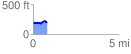
 0.821035 mi
 87.05 ft
 91.18 ft
 -4.13 ft
 2.10 %
GPX Downloads: Track Route
![]()
| at: |
Stephen F. Austin Experimental Forest |
show on map
animate
Wheelchair accessible.
Trail users:
0.821035 mi
87.05 ft
91.18 ft
-4.13 ft
2.10 %