| at: |
Angelina National Forest |
Data from USFS GIS
 show on map
 animate
Trail users:

Elevation Profile
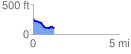
 1.219512 mi
 47.57 ft
 196.47 ft
 -148.90 ft
 3.05 %
GPX Downloads: Track Route
![]()
| at: |
Angelina National Forest |
show on map
animate
1.219512 mi
47.57 ft
196.47 ft
-148.90 ft
3.05 %