| at: |
Warwoman WMA |
Data from David Muse
 show on map
 animate
Trail users:


Elevation Profile
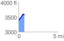
 0.746014 mi
 243.60 ft
 31.25 ft
 212.34 ft
 6.18 %
GPX Downloads: Track Route
![]()
| at: |
Warwoman WMA |
show on map
animate
0.746014 mi
243.60 ft
31.25 ft
212.34 ft
6.18 %