| at: |
Warwoman WMA |
Data from David Muse
 show on map
 animate
Trail users:


Elevation Profile
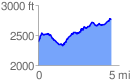
 4.550031 mi
 1139.54 ft
 755.12 ft
 384.41 ft
 4.74 %
GPX Downloads: Track Route
![]()
| at: |
Warwoman WMA |
show on map
animate
4.550031 mi
1139.54 ft
755.12 ft
384.41 ft
4.74 %