| at: |
Sabine National Forest |
Data from USFS GIS
 show on map
 animate
Trail users:


Elevation Profile
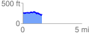
 1.621689 mi
 120.05 ft
 188.04 ft
 -67.99 ft
 2.20 %
GPX Downloads: Track Route
![]()
| at: |
Sabine National Forest |
show on map
animate
1.621689 mi
120.05 ft
188.04 ft
-67.99 ft
2.20 %