|
| at: |
Sabine National Forest |
Data from USFS GIS
 show on map
 animate
Trail users:


Elevation Profile
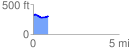
 0.888533 mi
 51.02 ft
 56.79 ft
 -5.76 ft
 1.21 %
GPX Downloads: Track Route
![]()
|
| at: |
Sabine National Forest |
show on map
animate
0.888533 mi
51.02 ft
56.79 ft
-5.76 ft
1.21 %