|
| at: |
Sabine National Forest |
Data from USFS GIS
 show on map
 animate
Trail users:


Elevation Profile
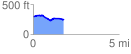
 1.776756 mi
 85.58 ft
 135.68 ft
 -50.10 ft
 1.45 %
GPX Downloads: Track Route
![]()
|
| at: |
Sabine National Forest |
show on map
animate
1.776756 mi
85.58 ft
135.68 ft
-50.10 ft
1.45 %