| at: |
Sabine National Forest |
Data from USFS GIS
 show on map
 animate
Trail users:


Elevation Profile
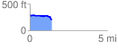
 1.424229 mi
 55.73 ft
 140.86 ft
 -85.14 ft
 1.87 %
GPX Downloads: Track Route
![]()
| at: |
Sabine National Forest |
show on map
animate
1.424229 mi
55.73 ft
140.86 ft
-85.14 ft
1.87 %