|
| at: |
Sabine National Forest |
Data from USFS GIS
 show on map
 animate
Trail users:


Elevation Profile
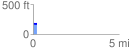
 0.211593 mi
 5.78 ft
 7.52 ft
 -1.75 ft
 0.67 %
GPX Downloads: Track Route
![]()
|
| at: |
Sabine National Forest |
show on map
animate
0.211593 mi
5.78 ft
7.52 ft
-1.75 ft
0.67 %