|
| at: |
Sabine National Forest |
Data from USFS GIS
 show on map
 animate
Trail users:


Elevation Profile
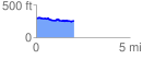
 2.014120 mi
 77.76 ft
 115.56 ft
 -37.80 ft
 1.09 %
GPX Downloads: Track Route
![]()
|
| at: |
Sabine National Forest |
show on map
animate
2.014120 mi
77.76 ft
115.56 ft
-37.80 ft
1.09 %